State Route 239 Scoping

Frequently asked questions

GENERAL / BACKGROUND

The project will provide a new four-lane highway from State Route 4 near Marsh Creek Road in Contra Costa County to Interstate 580 in Alameda County or Interstate 205 in San Joaquin County. This new state route will ultimately improve the transportation network for an area that has few viable north-south roadway connections in the nearly 17-mile stretch between eastern Contra Costa and San Joaquin counties. In addition, the project would support connections to emergency evacuation routes, reduce non-local traffic through the community of Byron, and enhance goods movement between eastern Contra Costa County and the Central Valley.

The project is currently in the environmental clearance phase, which is anticipated to be completed in 2024. We are actively seeking additional funding, and when funding becomes available, design will begin on an initial, fundable segment of the corridor.

The full 17-mile project will require further environmental analysis and subsequent design, after funding is identified and secured. The funding to date has been slow to develop and thus the process has moved slowly. In addition, this project traverses three counties and many jurisdictions, and developing a project of this size requires substantial stakeholder input. Recent environmental laws have added another layer of complexity to this project.

We have currently identified two build alternatives, shown in the figure below, that are being considered, along with a No Build project alternative. During this scoping process, we welcome ideas for additional alternatives that meet the project’s Purpose and Need. They may be carried forward for consideration and environmental study. The new route will be determined after an evaluation of the environmental impacts of all alternatives.

Figure: SR239 Project Alternatives

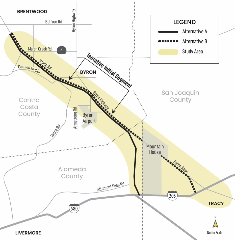
Caltrans is the lead agency under the National Environmental Policy Act (NEPA) and California Environmental Quality Act (CEQA). Caltrans is the owner and operator of the State Highway System in California and retains responsibility for overseeing and approving the environmental document under CEQA and NEPA. Contra Costa Transportation Authority is the project sponsor. Ultimately, after the corridor is constructed, the route will be transferred to Caltrans who will own and operate SR 239.

TRAFFIC

Construction effects will depend on the alignment selected and proximity to existing roadways. There may be temporary delays and detours during construction, particularly when existing roads are being connected to the new roadway. Traffic-related impacts will be evaluated in detail in the environmental document

One of the project goals is to support inter-regional north-south goods movement operations. The project would provide a more direct connection for trucks traveling between eastern Contra Costa and San Joaquin counties and would allow trucks to avoid passing through the town of Byron

One of the project goals is to reduce non-local traffic through the town of Byron. This project would provide a more direct route between Byron Highway and Vasco Road/SR 4, bypassing the Byron community.

TRANSIT & ALTERNATIVE MODES

There is a need to provide a viable north-south connection between eastern Contra Costa and San Joaquin counties. The project will evaluate multi-modal opportunities along the corridor, including transit, bicycle, and pedestrian facilities.

The project will include feasible transit options as part of the project.

The project will include construction of bike facilities with connections to transit stops and rail stations. The project will be designed to meet the Complete Streets policies of the surrounding jurisdictions. The public outreach effort includes bicycle advocacy groups.

The project alternatives will be revised and refined based on the comments received during this current scoping process and possible transit park-and-ride will be considered.

ECONOMY

There is planned development in the region that would benefit from improved transportation facilities. The project would also improve connections between eastern Contra Costa County and western San Joaquin County, which is also expected to support economic growth.

There is planned development in the region that would benefit from improved transportation facilities.

SR 4 is the only major evacuation route in eastern Contra Costa County. In the event of major catastrophe, which may have impacts to SR 4, evacuation routes in the area would be limited. A new connection to San Joaquin County would provide relief and an additional evacuation route.

Development along most of the project alignment in Contra Costa County is constrained by urban limits and the county’s no growth policy. Significant population increases along the alignment are not anticipated.

As the project is developed and project funding is evaluated, further study will be conducted.

EQUITY AND ENGAGEMENT

The project team has coordinated with local jurisdictions and permitting agencies, as well as other major projects in the area. The project team has participated in many community meetings and had several discussions with agency stakeholders.

During the environmental process, Caltrans and CCTA will reach out to Native American representatives for their input and concerns regarding cultural resources and tribal resources and will consult with Native American tribes as required by state and federal statutes.

The project team has coordinated with sponsors of major projects within the project area and that effort will continue.

ENVIRONMENT

Caltrans and CCTA circulated a Notice of Preparation under CEQA in December 2021. The federal scoping process will officially begin with issuance of a Notice of Intent at a date yet to be determined.

Issuance of the NOP begins the environmental review process and a combined Environmental Impact Report under CEQA and Environmental Impact Statement under NEPA is anticipated to be circulated for public review in 2023. A final EIR/EIS is anticipated in 2024.

Technical studies have commenced to evaluate the impacts of the project on wildlife, habitat, and wildlife movement. Caltrans and CCTA will be coordinating with federal and state agencies concerning these evaluations. Prior project alternatives that would have bisected conservation lands were rejected. The two current build alternatives minimize impacts to conservation lands that lie west of the project area and minimize the fragmentation of core habitat areas. Caltrans and CCTA will evaluate opportunities to incorporate wildlife crossings – such as enlarged culverts – into the design of the new roadway.

Technical studies have commenced to evaluate the impacts of the project on birds and other wildlife. The project may displace areas used for nesting by ground nesting and tree nesting birds. The project will likely require pre-construction surveys and frequent spot checks to ensure the project does not result in an impact to migratory birds and their nests.

Earlier in the alternatives development process, several alternatives that would have adversely affected conservation lands were dismissed from further evaluation. The remaining two builds would minimize encroachment onto existing conservation areas. Impacts to important farmland are also being considered in the environmental evaluation, and appropriate mitigation will be developed in coordination with project partners and private landowners.

The project will introduce a new highway in certain areas where no roadways exist and may expand existing roadways. This will result in a change to visual aesthetics in open space, agricultural and developed areas when compared to existing conditions. Visual aesthetics and lighting impacts will be evaluated during the environmental process. New lighting will be limited to key areas, such as interchanges and pedestrian crosswalks.

The project will result in greenhouse gas emissions during construction. The project’s operational effect on greenhouse gas emissions will depend on whether the project will increase vehicle miles travelled (VMT) or not. If the project will increase greenhouse gas emissions and they are determined to be significant, then Caltrans and CCTA will examine feasible mitigation to reduce regional VMT.

The project will result in the release of criteria pollutants and other emissions during construction. The project may also increase air pollutant emissions during operation of the new facility, depending on whether the project will increase VMT or not.

The project’s effect on VMT will be evaluated and disclosed as part of the environmental process.

PROPERTY

It is too early to determine project-related impacts on specific parcels since the final alignment has not been studied or selected. Once the potential impacts are known, they will be fully disclosed as part of the environmental process.

It is too early to determine or quantify project-specific impacts on agricultural resources. Once the potential impacts are known, they will be fully disclosed as part of the environmental process.

FUNDING

The project has federal and County funding to complete the environmental review process. The initial phase of the project, which is proposed to be the new roadway between Vasco Road and Byron Highway near Byron Airport, has Regional Measure 3 funding and additional funding is being sought. The project costs are being developed.

OTHER

The project will improve the connection to the Byron Airport. The County is updating the land use plan around the Airport and an environmental document is currently being finalized. Additional information on anticipated traffic is given in the Airport area planning document.